Article information:Please provide a full citation and/or link so that people can read the full paper.
Dr. NIU Xiaojing's team published an approach for quantifying nearshore tsunami height probability and its application to the Pearl River Estuary in the journal of Coastal Engineering. The study utilizes the constructed efficient analysis method and probability model to provide the spatial distribution of tsunami risk along the coastline around the Pearl River Estuary of China by analyzing the potential tsunami scenarios in millions.
Seismic tsunami is an unpredictable and highly destructive marine hazard. There have been many historical events in which seismic tsunamis have caused catastrophic damage and major casualties, such as the Indian Ocean tsunami in 2004, the Japanese tsunami in 2011, and the Indonesian tsunami in 2018. Relevant studies show that the Philippine Sea plate in the Manila Trench region on the eastern side of the South China Sea is rapidly subducting towards the Eurasian continental plate at a rate of 55-91 mm per year. Once the accumulated stress is suddenly released, the triggered large earthquakes will bring serious tsunami hazards to the coastal region of southern China. Thus, quantitative assessment of the tsunami risk induced by this threat in the South China Sea islands and mainland coasts can provide scientific support for the planning and design of coastal protection and sensitive facilities.
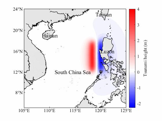
Tsunami process triggered by the Manila Trench earthquake
(epicenter location 119°E, 16°N, magnitude 9, depth 100 km, strike angle 0°, dip angle 30°, slip angle 90°)
The tsunami process triggered by a specific earthquake can be well simulated by high-precision ocean dynamics models. However, since the tsunami power triggered by an earthquake is affected by seismic parameters such as epicenter location, magnitude, depth, strike angle, dip angle, slip angle, which are strongly randomized and uncertain, the comprehensive assessment of tsunami risk is a very complex problem. Based on the linear assumption of tsunami waves in deep water, Dr. NIU Xiaojing's Team calculates tsunami wave propagation through the linear superposition of waves caused by unit sources of water level disturbance, which transforms a large number of seismic tsunami scenarios simulations into a limited number of simulations on wave propagating from each unit source. On this basis, the team has given a return period data set of tsunami wave heights in the South China Sea with a spatial resolution of 0.1°, which can be used as a boundary condition for near-shore risk assessment, and can also be used as a preliminary reference for tsunami risk in the planning of engineering and construction in the South China Sea and its neighboring areas.
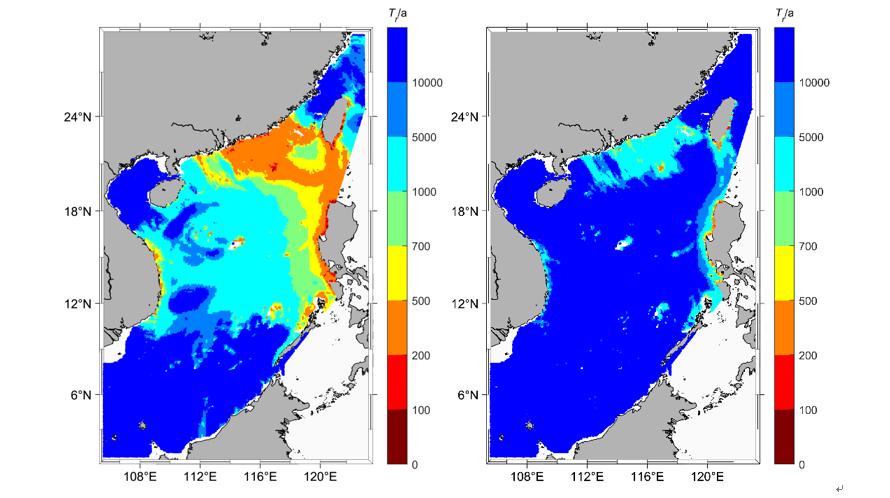
Spatial distribution of tsunami wave heights of 2m (left) and 5m (right) in the South China Sea corresponding to the recurrence period
The aim of this study is to quantify the exceedance probabilities of specific wave heights at the shoreline in order to assess tsunami hazard. A two-dimensional Boussinesq model is adopted to gain the amplification factor, which can take nonlinear, dispersion and dissipation into account. Moreover, the effect of incident wave period and wave height was considered to make more accurate estimation on the amplification factor. Thus, a joint possibility density distribution of tsunami wave height and period at offshore cites are firstly calculated. The tsunami wave height and period at the offshore site are analyzed based on simulations of enormous tsunami scenarios using the superposition approximation of Zhang and Niu (2020).

Joint probability density distribution of tsunami period and height at point TP0

The spatial distribution of the amplification factor (Wave amplitude is 0.1 m. Incident wave period is 40 min)
The study points out that the southern coastline of Zhuhai, the eastern coast of Hong Kong and the front of the offshore islands are areas at higher risk of tsunamis. The surrounding area of those points may be facing tsunami waves more than 5 m high under the condition of once-in-1000-years. More attention should be paid on those areas on tsunami disaster prevention and mitigation.

PNTA with return periods of 1000 years by using present approach
 Department of