Dr. SHANG Songhao's team published a monthly distributed agro-hydrological model for irrigation district in arid region with shallow groundwater in Journal of Hydrology. The study developed a novel monthly distributed agro-hydrological model for irrigation districts (DAHMID) based on the concepts of canal command area (CCA) and sub-drainage command area (SDCA). The model was applied to Hetao Irrigation District (HID), and the simulation revealed the mechanism and law of agro-hydrological processes in HID.
Irrigation plays an essential role for food production in arid and semi-arid regions. Intense evapotranspiration potential and scarce precipitation usually lead to severe water scarcity and fragile ecosystems in these regions. Therefore, agricultural production relies heavily on the irrigation water diverted from river and/or pumped from groundwater in irrigation districts of arid regions. Agriculture consumes about 70% of global fresh water, and approximately 90% of it is used for irrigation purpose. However, improper irrigation and drainage practices usually result in groundwater table rising, which then induces waterlogging and salinity problems that threaten crop growth.
Unlike the traditional hydrological processes in natural watersheds that are mainly controlled by natural factors, agro-hydrological processes in arid irrigation districts are also greatly influenced by anthropogenic factors. Traditional watershed hydrologic modeling is difficult to apply directly to arid irrigation districts.
In present study, a novel distributed agro-hydrological model (DAHMID) is developed, which has less parameters, requires less data, and can realize distributed hydrological simulation in large irrigation districts. By dividing simulation units with different inputs and parameters, the DAHMID model can simulate typical hydrological processes in arid irrigation districts with shallow groundwater table, such as groundwater table fluctuation, capillary rise, and interior drainage in the whole irrigation district or each CCA. The study region of HID is characterized with different land use types, soil textures, and crop planting pattern. The simulation results show that the DAHMID model is applicable to different underlying surfaces.
The main findings from this study are as follows:
(1)The annual interior drainage of the whole irrigation district is 559–713 million m3, which is 34.9% more than the drainage through ditches and accounts for 12.87%-14.98% of the irrigation water amount. The interior drainage process is similar to irrigation and ditch drainage processes, all reaching their peaks in May and October. Spatially, interior drainage is more effective in WLBH and the middle and southern YC, and less effective in the northern WLT, which is directly related to the area ratio of irrigated land to non-irrigated land.
(2)Total ET is the major water consumption in HID, which is about 95% of total irrigation water diversion and precipitation in average. Annual ET is mainly controlled by irrigation and precipitation, and varies significantly with land use types from about 200 mm in desert and 1000 mm in water bodies. Meanwhile, monthly ET changes with meteorological factors, land use types, and crop growth period in cropland.
(3)The annual net capillary rise of irrigated land (33–81 mm) is significantly lower than that of non-irrigated land (162–225 mm) due to the impact of irrigation infiltration. The process of capillary rise in irrigated land is inconsistent with that of groundwater table because of the suppression of irrigation, while these two processes are basically the same for non-irrigated land.
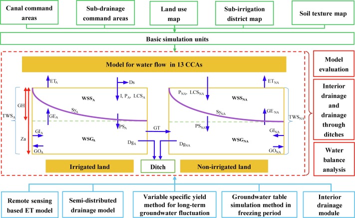
Schematic diagram of the DAHMID model
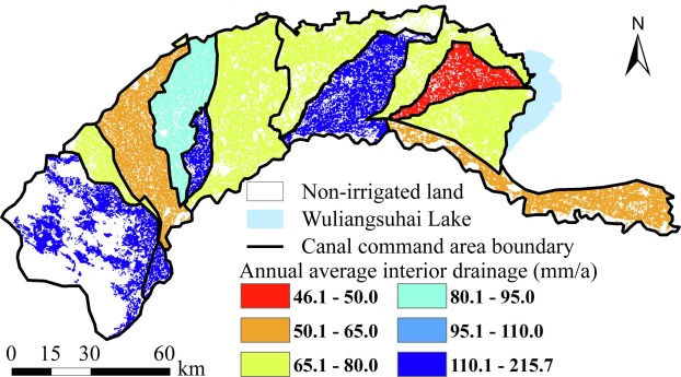
The distribution of annual average interior drainage of irrigated land in different CCAs
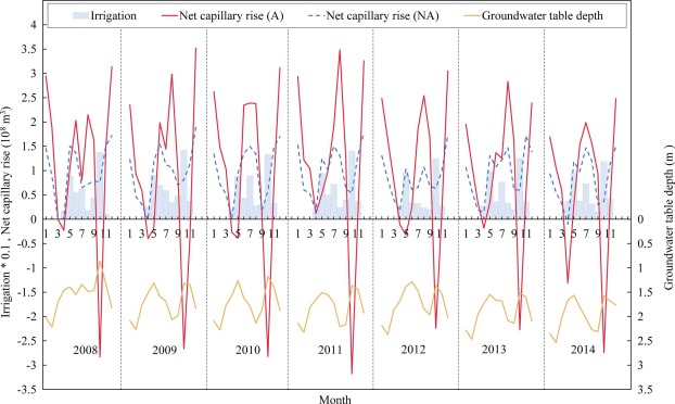
Monthly net capillary rise processes of irrigated (A) and non-irrigated (NA) lands and irrigation and groundwater
table depth processes of the whole HID from 2008 to 2014
 Department of