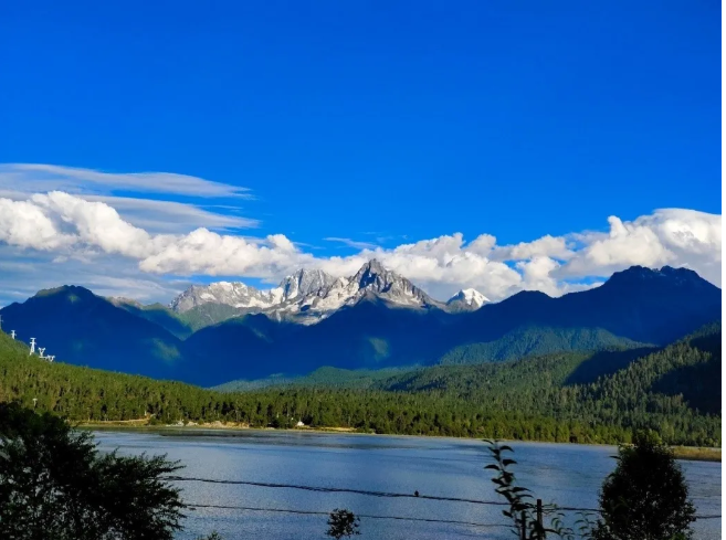
Expedition overview
The Qinghai-Tibet Plateau is also called “the water tower of Asia” and “the third pole of the Earth.” With an average altitude higher than 4000 meters, the Qinghai-Tibet Plateau is the origin of many rivers, such as the Indian River, the Ganges, the Yarlung Tsangpo and Brahmaputra River, the Nujiang and Salween River, the Lancang and Mekong River, the Yangtze River, the Yellow River, etc. Since the region is under the influence of both westerly and monsoons and abundant water resources in the shape of rivers, lakes, and glaciers, changes in the water reserves and water cycle process in multiple river basins will directly affect the utilization of water resources and the prevention and control of water disasters. Research has shown that the Qinghai-Tibet Plateau is, globally, one of the most sensitive regions to climate change. In recent years, there has been an apparent upward trend of warming and humidification in this area. Phenomenon like the continuous melting of glaciers and the expansion of lakes mean that the water reserves and hydrological cycle processes within the region will undergo profound changes. These events would bring more challenges to the utilization of water resources and the prevention and control of water disasters within the Qinghai-Tibet Plateau and downstream regions(Han et al. 2019; Li et al. 2019a; Sun et al. 2020). This scientific expedition aims to investigate the hydrological conditions of typical rivers, lakes, and glaciers in southeastern Tibet and to support relative research of the second comprehensive scientific expedition of the Qinghai-Tibet Plateau “The impacts of the synergy of westerly and monsoons on the water tower of Asia.”
The scientific expedition team composed of the Hydrological Remote Sensing Research Group of the Department of Hydraulic Engineering of Tsinghua University began their 16-day expedition from August 11th to August 26th, 2020. The team traveled to the Yarlung Tsangpo River and its tributary the Lhasa River, the Nam Co Lake, the 24K(Galung La) Glacier, the Zhuxi Glacier, and the Midui Glacier. Under the leadership of Prof. Di Long, Qi Huang, Pengfei Han, Xingdong Li, Xueying Li, Fanyu Zhao, Zhongkun Hong, and Caijin Zhang, a total of eight members participated in this scientific expedition. The scientific expedition team members arrived in Lhasa between August 11th to 12th, and the team passed through Lhasa, Damxung, Nyingchi, Milin, Bomi, and other counties and cities, with a total distance of nearly 3,000 kilometers and an altitude range of 2040-5200 meters. The expedition team maintained three water level gauges in different river basins, closely inspected three glaciers, visited Nam Co and Nam Co’s multi-circle comprehensive observation and research station, and conducted sampling and measurement in key areas. The accumulated valuable measured data helped to changes in water reserves on the Qinghai-Tibet Plateau. The research results will provide the crucial scientific basis for creating a response protocol related to the impacts of global warming on the water tower of Asia.
01 River investigation - adjusting water level gauge and obtaining measured run-off data
The Hydrological Remote Sensing Research Group of the Department of Hydraulic Engineering of Tsinghua University was supported by the National Natural Science Foundation of China’s “Southwest Run-off Major Research Program” key project “Multi-source remote sensing observation and data integration of key hydrometeorological variables in the origin regions of the southwest rivers.” The research group installed multiple radar water level gauges and started observation tasks in the Yarlung Tsangpo River and its tributary the Lhasa River, the typical Qinghai-Tibet lake Nam Co Lake, the Yamdrok Lake, and other places during 2016-2019. During this expedition, three of the water level gauges were maintained and adjusted. The team maintained the Lhasa River water level gauge on August 12, 2020, maintained the downstream water level gauge of the Nuxia Hydrological Station on the Yarlung Tsangpo River on the 16th, and maintained the water level gauge of the Nuxia Hydrological Station on the Yarlung Tsangpo River on the 25th. The expedition team also inspected the rivers along the way, furthering the understanding of hydrological elements such as volume, velocity, and water level of water flow of the main and tributaries of the Yarlung Tsangpo River.
On August 12th, the expedition team first went to the Lhasa River to adjust the water level gauge. The Lhasa River is one of the most important tributaries of the Yarlung Tsangpo River. Originated from the Nyainqentanglha Mountain, the Lhasa River has a drainage area of about 31,000 squared kilometers, and the river width is less than 100 meters during the low run-off period. The installed radar water level gauges are composed of a sensor, a remote terminal unit (RTU), and a bracket. The water level gauges use the Ku band for measurements. The working principle behind the water level gauges is to calculate the distance from the instrument to the water surface through the two-way propagation time of the radar pulse signal, subtracted from the distance from the water level gauge to the reference datum surface to obtain the distance from the water surface to the reference datum surface (ie water level). During the entire tuning process, the scientific expedition team members had a clear division of labor and efficient collaborations. Among them, Pengfei Han, Xingdong Li, and others were responsible for connecting the water level gauge probe to the terminal, Qi Huang was responsible for setting the parameters for the terminal, and the rest of the team assisted in fixing the water level gauge bracket (see Figure 1). After confirming that the water level gauge probe could measure and transmit data correctly, the team returned to Lhasa. So far, the maintenance of the Lhasa River water level gauges has been successfully completed.
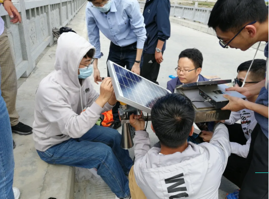
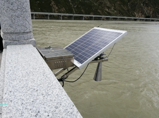
Figure 1 The maintenance and adjusting of the Lhasa River water level gauges:
(1) The scientific expedition team members are performing equipment replacement, debugging, and installation of the water level gauge;
(2) The water level gauge that works correctly after the installation
On August 16th, the scientific expedition team inspected key sectors in the middle and lower drainage area of the Yarlung Tsangpo River. The Yarlung Tsangpo River has complex hydrological processes (such as glaciers, snow accumulation, and melting) and is also very sensitive to climate change. The Yarlung Tsangpo River also plays a vital role in supplying drinkable water and agricultural irrigation in China and downstream countries like India, Bangladesh, and so on. Given the important role of the Yarlung Tsangpo River, there is a lack of relevant observational data in the Yarlung Tsangpo River Basin, and the river channels are mostly braided with severe erosion on the riverbanks. The two water level gauges being maintained this time are located in the upper and lower reaches of Pai town, Milin county. After inspection and debugging, the terminal located at the Luxia Bridge (Nuxia Hydrological Station), upstream of Pai town, cannot display data. After preliminary judgment, the cause of the failure might be a damaged terminal, solar panel, or the three-hole aviation plug of the solar panel these three situations. As a solution, the scientific expedition team members locally purchased and replaced solar panels, ensuring the booting of the system. However, during the process of adjusting parameters and transmitting data, it was found that the terminal was malfunctioning and could not simultaneously send data to the server in the Department of Hydraulic Engineering of Tsinghua University. As a result, it was necessary to contact the manufacturer and deliver a new terminal to Linzhi. On August 25th, the new terminal was delivered to Linzhi from Shandong. Team members tested the terminal and returned to the Luxia Bridge to replace the old one. Finally, the water level gauge functioned normally and could provide real-time water level data of the measured section (see Figure 2). Another water level gauge located downstream of Pai town (downstream of the Nuxia Hydrological Station) could not send data because the configured SIM card has expired. After replacing it and adjusting the water level gauge, the equipment worked normally (see Figure 2).
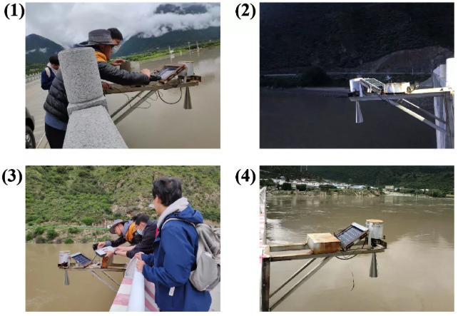
Figure 2 The maintenance and adjusting of water level gauges on the Yarlung Tsangpo River:
(1) Team members inspecting the condition of the water level gauge at the Luxia Bridge, upstream of Pai town;
(2) The upstream water level gauge that works properly after replacing the terminal;
(3) Team members replacing the SIM card and adjusting the equipment of the downstream water level gauge of Pai town;
(4) The well-functioning downstream water level gauge after debugging.
The maintenance of the equipment went relatively smoothly this time. Through the joint efforts of the members of the science expedition team, the maintenance of the water level gauges was successfully completed, and the team also obtained valuable actual measured data of water levels which can be used as a supplement and verification for using the satellite to measure high water levels. The Hydrological Remote Sensing Research Group of the Department of Hydraulic Engineering of Tsinghua University used the installed water level gauge observation data and multi-source satellite remote sensing to carry out remote sensing inversion and hydrological simulation of the water level and relevant researches of the narrow rivers in the mountainous area. Many results have been published in the top periodicals of remote sensing and hydrology (such as Remote Sensing of Environment and Water Resources Research), which include: (1) In order to overcome the interference of complex terrain and narrow river channels in the high-altitude areas on spaceborne radar echo signals and retrieve high-precision river water levels, we developed a new waveform resetting algorithm (50% Threshold and Ice-1 Combined algorithm,TIC) based on satellite altimetry technology (including Envisat, Jason-2/3, SARAL/AltiKa, Sentinel-3A, etc.) and the measured water level data. The algorithm has been rigorously tested, and it could effectively solve the problem of correcting the vertical distance of a narrow channel (a hundred-meter-level river width) (Huang et al. 2019; Huang et al. 2018a); (2) Based on three different typical cross-section forms, the Manning formula, and the river width and water level data retrieved from remote sensing, a method for estimating river flow in areas lacking data have been developed(Huang et al. 2018b); (3) Carried out satellite altimetry and SWOT-like data (actual measured water level and observed river width of Landsat 5/8) calibration model application test, achieving continuous simulation of daily runoffs without measured runoffs and provided a hydrological model framework(Huang et al. 2020) for future SWOT satellite data applications; (4) The water surface elevation and water surface area obtained by multiple satellites are used to estimate the water storage change of the reservoir, and verified by the measured data of water level gauge, further coupling the hydrological model and the reservoir operation rules to achieve the daily-scale outflow simulation of the reservoir in the data-deficient areas((Han et al. 2020) .
02 Lake investigation - visiting the observation station and field investigation
The Nam Co Station for Multisphere Observation and Research Station of the Chinese Academy of Sciences is located on the southeast bank of Nam Co Lake, backed by the Nyainqentanglha Mountains, belonging to a typical semi-arid plateau monsoon climate zone. Since the establishment of the station, the research station has carried out various field monitoring tasks in the Nam Co watershed, mainly includes: atmospheric physical observation, hydrological observation, glacier and frozen soil change monitoring, vegetation phenological change monitoring, etc., providing valuable data for research in the fields of hydrology and ecological environment.
On August 14th, the scientific expedition team visited the Nam Co Station for Multisphere Observation and Research Station of the Chinese Academy of Sciences. The highest altitude on the way exceeded 5,100 meters. Under the guidance and explanation of the staff(see Figure 3), the scientific expedition team members learned about the uses of various instruments and the observation principles behind them. The instruments deployed in the station mainly include rain gauges, solar photometers, snow detectors, water surface evaporation pans, differential GPS, microbial carbon fixation experimental experiment, environmental observation stations, etc. (see Figure 4). The station has many instruments for measuring the snow state, including an automatic snow depth observer composed of a snow ruler and a camera (the snow depth can reach 50-60 cm between November and mid-February each year) and a giant snow water equivalent measuring instrument. Among them, the snow water equivalent observer measures the weight of snow on the sleeper through the load cell built into the sleeper, that is, the snow water equivalent. The equipment can also combine the snow thickness, measured by the snow depth sensor, to obtain the snow density. In addition, the equipment that occupies the largest area in the station is the observation system of vegetation phenology, which is used to explore the impact of precipitation differences on the growth of vegetation on the plateau. The earliest and largest equipment installed in the station is an atmospheric boundary layer observation tower with a height of tens of meters, which can observe the atmospheric state variables such as pressure, temperature, humidity, wind and energy transmission sate at different heights. Besides the observations happening inside the station, the staff also conduct annual observations of Nam Co Lake, rivers that enter the lake, and surrounding glaciers. For example, the observation of lake ice is carried out once a year (usually in February when the lake ice is the thickest). The staff would drive motorcycles to the center of Nam Co Lake and drill holes with steam drills along the way to measure ice thickness
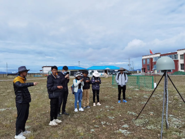
Figure 3 The staff introduces the relevant information of the observation station to the members of the scientific expedition team
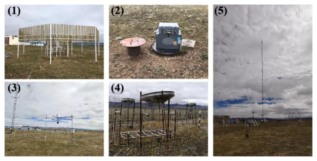
Figure 4 Some of the instruments and equipment of the Nam Co Station for Multisphere Observation and Research Station of the Chinese Academy of Sciences:
(1) A large rain gauge (currently under construction);
(2) A sun photometer;
(3) A snow detector;
(4) A vegetation phenology observation system;
(5) An atmospheric boundary layer observation tower
In addition, the scientific expedition team members also went to Nam Co Lake for field investigation. Nam Co Lake covers about 2,000 square kilometers and is the second largest lake in Tibet. Due to most of its 21 main rivers that enter the lake are located on the south bank of the lake, the team mainly investigated along the south bank. Over the past ten years, Nam Co Lake has shown an overall increase in water reserves and the phenomenon of are expansion. In order to explore the changes in lake water reserves on the Qinghai-Tibet Plateau, team members have combined multi-source altimetry satellites and remote sensing cloud computing technology to develop a high-time resolution water level and water volume change data set of 52 large lakes on the Qinghai-Tibet Plateau (including Nam Co Lake). The results were published in a top Earth science journal called Earth System Science Data (Li et al. 2019b). During the field investigation, some members went to maintain the pressure-type water level gauge previously installed, and others went to the Tashi Penisula for field investigations. Soon after, the team members went to Niyaqu to visit the installed weather station and water level gauge (see Figure 5).
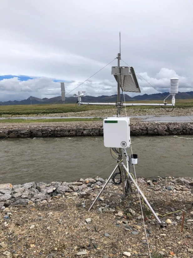
Figure 5 The weather station and the water gauge located on the bank of the Niyaqu River
03 Glacier investigation - understanding the glacier structure on scene
Southeastern Tibet is located at the intersection of the Himalayas, Nyainqentanglha, and Hengduan Mountains, with high mountains and deep valleys. The monsoon brings a lot of precipitation which interacts with the special valley topography in southeast Tibet, resulting in the development of many large-scale ocean-type glaciers. The total area of glaciers in this area is more than 6,000 square kilometers, with huge ice reserves and extremely rich freshwater resources. However, in recent decades, as the temperature rises and the inter-annual fluctuation of precipitation increases, southeastern Tibet has become the most obvious area of glacier retreat in the entire Qinghai-Tibet Plateau. The drastic glacier changes directly affect the agriculture, economy, and the production and life of residents along the river. In order to understand the current status and changing characteristics of glaciers in southeastern Tibet, the scientific research team inspected three typical marine glaciers in southeastern Tibet from August 18th to 20th: 24K (Galongla) glacier, Taohuagou Zhuxi Glacier, and Midui Glacier.
On August 18th, the scientific expedition team climbed the eastern branch of the 24K glacier (Glacier NO. 1). The surface of the Dongzhi Glacier’s ice tongue was full of moraines, and there were huge boulders with one or two meters in diameter, and there were also palm-sized gravels. The stone was broken and sharp, making it very difficult to climb. During the climb, the scientific expedition team encountered multiple ice holes and three relatively large ice cracked (see Figure 6). Most of the ice around the ice cracks were bare or covered with a thin moraine, and due to the ice melted faster than the surroundings, the surrounding debris constantly slid to the bottom of the ice cracks. Ultimately, the scientific expedition team reached the position of 4,016 meters above sea level. Here one could see the full view of the 24K Glacier west branch (Glacier MO.2), the small waterfall formed by the small glacier on the side of the east branch glacier, and two huge ice cracks. On the return journey, at the end of the glacier where the meltwater flows out (about 3,850 meters above sea level), it could be observed that the ice thickness was about 10 meters, the width of the ice wall was about 200 meters, and moraines and ice blocks were constantly falling from above (see Figure 6). The glacier meltwater water flow was large, reflecting the rapid melting speed of the glacier. According to documentary records, in 2012, the ice thickness at the end of the eastern branch of the 24K glacier was 32 meters, and there was a glacial lake with a diameter of about 60 meters at the end. Now the thickness of the end is only about 10 meters, and the original glacial lake has dried up and also been far away from the end. Considering the retreat of the glacier and the slope factors, the surface elevation of the end of the slope factors, the surface elevation of the end of the 24K east branch Glacier dropped by more than 3 meters per year during this period, which shows the rate of glacier melting. This is a common feature of the entire southeastern Tibet, and it is urgent to protect glacier resources.
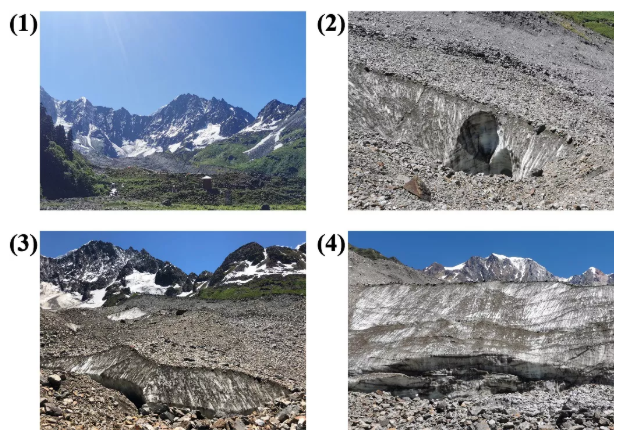
Figure 6 Field investigation of 24K glacier:
(1) Overlooking the eastern branch of 24K glacier;
(2) Melting ice cave;
(3) Ice crack;
(4) Glacier end.
On August 19th, the scientific expedition team went to Taohuagou Zhuxi Glacier (located on the left side of Bodui Zangbo River) for an investigation (see Figure 7). The scientific expedition team walked through a dense forest, and along the meltwater stream of the Zhuxi Glacier, they saw two large blocks of ice that were melting. The larger one formed an ice cave over 3 meters high (see Figure 7), and the ice at the top of the cave was continuously melting into water droplets. Presumably, these ice blocks slid from higher altitude areas in the winter. Afterward, some members continued to go up into the forest, preparing to proceed to the foot of the glacier. Along the way, they saw a moss-covered forest and a spruce tree with a height of seventy or eighty meters and took three people hands to hands to hug the tree all around. At last, the team waded across the river to reach the location where the glacier meltwater on both sides of the Zhuxi Glacier converge. From here, one can see the larger glacier on the left and the smaller glacier on the right that is melting away. The amount of meltwater on both sides of the glaciers was huge, with turbulent streams.
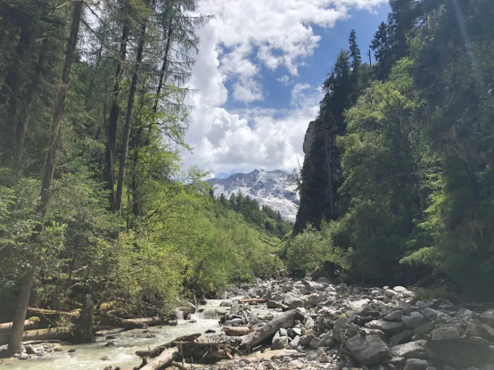
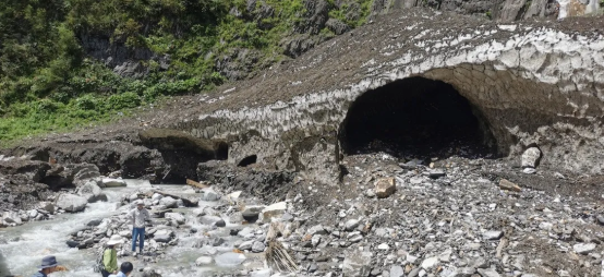
Figure 7 Field investigation of the glaciers in Taohuagou:
(1) Overlooking the Zhuxi Glacier in Taohuagou;
(2) A melting ice cave
On August 20th, the scientific expedition team went to Midui Glacier for investigation. The Midui Glacier is about 100 km away from the town of Bomi, and the glacier has been developed into a tourist attraction. The scientific expedition team took pictures of the Midui Glacier at different locations on the viewing platforms in front of a proglacial lake, the Guangxiecuo Lake (see Figure 8). When compared with pictures of the Midui Glacier taken in September 2019, it can be seen that the water level of the proglacial lake Guangxiecuo Lake has risen slightly, while the ice tongue has receded more and the thickness has become significantly thinner. The surface area of Guangxiecuo Lake has expanded from 0.11 square kilometers in 2001 to 0.43 square kilometers in 2019. The current surface area is comparable with the surface area before the glacial fluctuation, causing a dam failure of the Guangxiecuo Lake in 1988 (0.44 square kilometers), but the water level was still far away from the level in 1988. Judging from the current situation, Guangxiecuo Lake will not have a dam failure in the near future. However, if the Midui Glacier undergoes glacial fluctuation or ruptures of the ice tongue, and a large amount of ice body falls into the lake, it is very likely that a dam failure will occur and causing serious natural disasters.
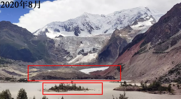
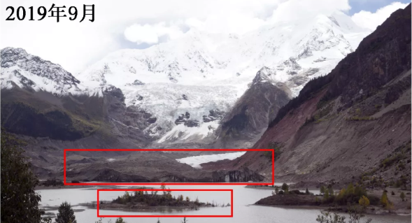
Figure 8 Comparison of photos of the Midui Glacier in 2019 and 2020
Thoughts on the scientific expedition
The scientific expedition lasted for 16 days while covering nearly 3,000 kilometers. Team members were full of enthusiasm, overcoming altitude sickness and other challenges, and successfully completed the scientific expedition for typical rivers, lakes, and glaciers in southeastern Tibet. Through installing and debugging field observation equipment, team members have deepened their understanding of the instruments’ working principles and improved their abilities to solve practical problems. Through visiting the Nam Co Station for Multisphere Observation and Research Station, team members have further mastered the application of various hydrometeorological observation instruments and also realized the hardships of stationing in a field observation station. Through climbing glaciers, team members learned about the structure and morphology of moraines, ice cracks, and ice caves, and also deeply understood the glacier melting situation in southeastern Tibet. This scientific expedition not only sharped the will of the team members but also improved everyone’s understanding of cryosphere hydrology and other subjects. This expedition also encouraged everyone to continue to actively explore in scientific researches, and achieve new heights.
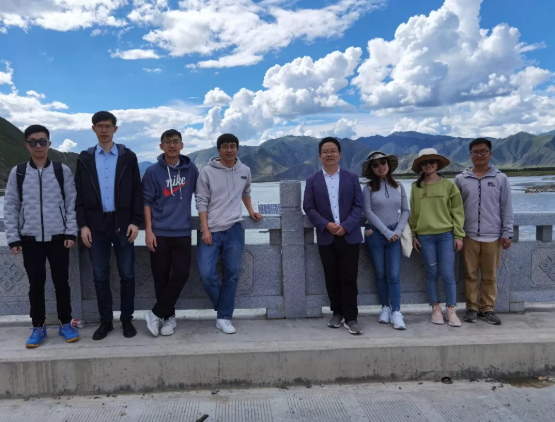
Figure 9 Group photo of the team members (taken at the water level gauge on the Lhasa River)
References
Han, P., Long, D., Han, Z., Du, M., Dai, L., & Hao, X. (2019). Improved understanding of snowmelt runoff from the headwaters of China's Yangtze River using remotely sensed snow products and hydrological modeling. Remote Sensing of Environment, 224, 44‒59
Han, Z., Long, D., Huang, Q., Li, X., Zhao, F., & Wang, J. (2020). Improving reservoir outflow estimation for ungauged basins using satellite observations and a hydrological model. Water Resources Research, 56, e2020WR027590
Huang, Q., Li, X., Han, P., Long, D., Zhao, F., & Hou, A. (2019). Validation and application of water levels derived from Sentinel-3A for the Brahmaputra River. Science China Technological Sciences, 1760‒1772
Huang, Q., Long, D., Du, M., Han, Z., & Han, P. (2020). Daily continuous river discharge estimation for ungauged basins using a hydrologic model calibrated by satellite altimetry: Implications for the SWOT mission. Water Resources Research, 56, e2020WR027309
Huang, Q., Long, D., Du, M., Zeng, C., Li, X., Hou, A., & Hong, Y. (2018a). An improved approach to monitoring Brahmaputra River water levels using retracked altimetry data. Remote Sensing of Environment, 211, 112‒128
Huang, Q., Long, D., Du, M., Zeng, C., Qiao, G., Li, X., Hou, A., & Hong, Y. (2018b). Discharge estimation in high-mountain regions with improved methods using multisource remote sensing: A case study of the Upper Brahmaputra River. Remote Sensing of Environment, 219, 115‒134
Li, X., Long, D., Han, Z., Scanlon, B.R., Sun, Z., Han, P., & Hou, A. (2019a). Evapotranspiration estimation for Tibetan Plateau headwaters using conjoint terrestrial and atmospheric water balances and multisource remote sensing. Water Resources Research, 55, 8608‒8630
Li, X., Long, D., Huang, Q., Han, P., Zhao, F., & Wada, Y. (2019b). High-temporal-resolution water level and storage change data sets for lakes on the Tibetan Plateau during 2000–2017 using multiple altimetric missions and Landsat-derived lake shoreline positions. Earth Syst. Sci. Data, 11, 1603‒1627
Sun, Z., Long, D., Yang, W., Li, X., & Pan, Y. (2020). Reconstruction of grace data on changes in total water storage over the global land surface and 60 basins. Water Resources Research, 56, e2019WR026250
Special thanks: this scientific expedition was funded by the “The second comprehensive scientific expedition of the Qinghai-Tibet Plateau” project (2019QZKK0105)
Authors: Xueying Li, Qi Huang, Fanyu Zhao, Caijin Zhang, Xingdong Li, Zhongkun Hong, Pengfei Han, Di Long
All rights reserved.